
Geology
Fathom Five National Marine Park

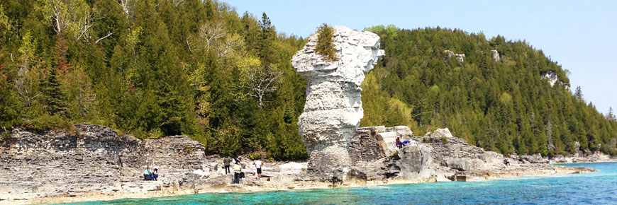
Flowerpot Island
© Parks Canada
The Niagara Escarpment stretches from Tobermory to Niagara Falls. The Bruce Trail follows it 782 km (486 miles) from Little Tub to Queenston Heights.
The islands of Fathom Five National Marine Park are part of the same formation which straddles the Great Lakes, stretching like the rim of a great stone platter across south Manitoulin Island and around the far side of Lake Michigan, where another peninsula, the Door Peninsula, forms a mirror image of the Bruce at Green Bay.
These rocks are dolomite, formed over 400 million years ago in a warm, shallow sea much like the Gulf of Mexico today, at a time when fish with backbones were the latest thing, and the first primitive land plants were appearing.
Earlier in this century, it was discovered that the earth’s continents are slowly moving over its surface. This phenomenon is known as "plate tectonics," and through its study we have determined that since these rocks were formed our continent has drifted quite a distance over the earth’s surface. Back then, the land around here was down near the equator. It’s moved north and now we're about halfway between the equator and the North Pole.
In those days, twice as long ago as the age of dinosaurs, there were great coral reefs here. The shells of those countless marine creatures, made largely of calcium, built up for millions of years. As the sea slowly dried up, magnesium in the water infiltrated the calcareous ooze, causing it to eventually turn into dolomite, which is similar to limestone but harder.
Submerged Geology
Staff from the Geological Survey of Canada, members of the Ontario Marine Heritage Commitee and Parks Canada staff have been working on a number of submerged geological research projects. Over the past three years many exciting geological features have been studied. Some of the features being studied are indicated below. This is a long term study and further investigations are being planned for next season.
Pop-up
During the side-scan sonar survey of the lake bed, a significant geological feature, known as a pop-up, was located and mapped in the area northeast of Echo Island. Pop-ups are generally attributed to near-surface stress releases in the bedrock. They are also referred to as rock heaves or pressure ridges. This particular pop-up is one of the largest underwater features of its kind found to date in southern Ontario. Running in a northwest-southeast direction, it is approximately 1750 metres (5775 feet) long and rises sharply up to five metres (16.5 feet) high from the generally level lake bed. Along the top of this ridge is a crack, or fissure, which varies from a metre to over 6 metres wide (wide enough at one point that the submersible was able to set right down inside the crack). Mapping and filming is expected to continue in future seasons.
Features like this help scientists to measure the isostatic rebound (the springing back of land-forms after the glaciers melted during their retreat). This rebounding is still occurring today.
Submerged Waterfall
The term "submerged waterfall" has generated much confusion. How can you have a waterfall when no water is falling? Some 10, 000 to 5000 years ago, the melting glaciers were creating the structure of today’s Great Lakes. Water levels have had many major ups and downs, and much of what now lies underwater between the Bruce Peninsula and Manitoulin Island was dry land, except for rivers and "gigantic" waterfalls. Water from the west (Lake Huron) actually drained to the east (Georgian Bay) through at least two large rivers, through the present day North Bay area and down the Ottawa River to the Atlantic Ocean. One of these rivers was located near Middle Island. That portion of the Niagara Escarpment, while submerged today, was exposed and the river plummeted over this portion of the cliff creating at first a "waterfall" and later eroding to become an enormous set of rapids some 800 metres (2640 feet) long, 1000 metres (3300 feet) wide and with a drop of 40 metres (132 feet). It likely carried as much or more water than Niagara Falls does today. Sadly, however (for our tourism potential) the glaciers continued to melt, water levels increased, land forms rebounded and the Great Lakes (as we know them) were formed. Our "waterfall", now submerged under the waters of Georgian Bay, is lost to sight but continues to aid scientists in their reconstruction of the geological history of this area.
Confirming Evidence

Submerged ancient tree
© Parks Canada
Scientists have long had theories about ancient lake levels, but it’s always nice to find confirming evidence. In several areas of the park, scientists have located the remains of ancient trees still rooted solidly into the lake-bed. These ancient trees have been found at depths from 3 to 43 metres (10 to 142 feet). Carbon 14 dating can accurately determine the age period of these trees. One of the oldest found within Fathom Five National Marine Park was off of Cove Island and was dated at 7490± years B.P. (Before Present.) By comparing the level at which the tree was growing and its age, previous lake levels can be confirmed.
Submerged Prehistoric Shoreline Study
There was a time, back before Egypt’s pyramids had been built, when a land bridge existed between what is now the Bruce Peninsula and Manitoulin Island. This land bridge would have allowed migration of wildlife and the hunters that followed them. By close examination of submerged landforms, such as ancient river beds and lakes, research teams look for potential sites that ancient travellers might have used as encampments.
Members of the Ontario Heritage Committee utilized the SDL-1 submersible in their search for such sites. This study will continue as the research team searches for archaeological evidence of activity by the First Nations along this ancient, now submerged, land bridge.
Related links
- Date modified :