
Water Temperature
The water temperature of the South Nahanni River and its principal tributaries is very low. During extended periods of hot weather, the water temperature may rise to 15oC, but typically, the during the summer months water temperature varies between 5oC and 10oC.
Hypothermia is a significant risk in the event of a canoe capsize or other unplanned swim. During immersion, the onset of hypothermia will be very rapid and represents a considerable threat to life. Even after rescue, a victim may continue to cool and unconsciousness and death can follow. Heat from an external source such as a campfire, warm fluids (not alcohol) or another person's body heat is essential. Simply covering the victim is not sufficient to replace body heat. Wearing a wet suit will increase the amount of time you are able to stay in cold water without developing hypothermia. Wet suits are a good precaution if you are whitewater paddling. Learn about hypothermia before your trip.
![]()
Water Levels
The water level of the South Nahanni River changes rapidly in response to snow melt and precipitation. Periods of maximum flow usually occurs in early to mid-June, and safely navigating the river at this time is difficult. Water levels can rise and fall rapidly throughout the summer months and changes are often generated by rain storms and surface run-off. In an average year, there will be eight to 12 flood events during the spring melt.
It is imprudent to camp on low ground near tributary mouths or close to the bank of the main river during periods of wet weather. Rising water levels can also make travel on the river more difficult. It may be advisable to wait out periods of high water. August is typically the month with the most stable water levels.
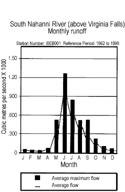
Graph representing the monthly runoff of the South Nahanni River
©Parks Canada
View a detailed description of this graph in accessible text format.
![]()
Flash Floods
A water level that rises and falls rapidly with little or no advanced warning is called a flash flood. Flash floods usually result from intense rainfall over a relatively small area, such as an intense thunderstorm at high elevations. Generally, precipitation increases with elevation. Rainfall and thunderstorms are most common in July, yet can occur anytime between June and September.
The topography of the land can increase the intensity (energy) of a flood. Steep and narrow drainages such as mountain valleys and canyons have a high potential to flash flood. This rapid runoff can wash an area clean of soil and vegetation, often leaving behind slumped areas and a valley floor of rocks and boulders. Nahanni National Park Reserve has many such valleys and canyons, such as Dry Canyon Creek, Prairie Creek, and Lafferty Creek. In 1995, one person died in a flash flood while hiking along Dry Canyon Creek.
Flash floods can kill. The following safety precautions may help to ensure a safe hike:
- Never hike alone.
- Each person should carry a rope or throw bag. Throw bags should be standard equipment for canoe or raft trips.
- Be watchful of localized weather systems, especially at higher elevations.
- In high energy stream beds look for the high water mark. Erosion and lack of vegetation will define these areas.
- Valleys with a steep gradient and narrow cross section are prone to flash floods.
- Be aware of possible escape routes.
- Don't camp in areas of flash flood potential.
Area of High Flash Flood Potential
Clearwater Creek, located approximately 11 kilometres downstream from Virginia Falls has been identified as an area with extreme flash flood potential. Between August 1996 and March 1997, there were five recorded seismic events in the area. Perhaps as a result of these earthquakes, during the winter of 1996-97, a large landslide occurred at the confluence of Clearwater and Cathedral creeks, approximately 17 kilometres upstream of the South Nahanni River. The landslide effectively blocked both creeks, and two lakes began to form behind this large earthen and rock dam.
In July 1997, portions of the natural dam collapsed, and the new 5km-long lake on Clearwater Creek dropped by more than 15 metres. This incredible volume of water surged downstream to the South Nahanni River resulting in a brief yet extreme flood event. No injuries were reported, although groups camped downstream had to pack up quickly in the night, and get into their canoes to ride out the flood, which saw water levels on the South Nahanni in Deadmen Valley rise by more than 4 metres overnight.
The stability of the portion of the dam that remains is uncertain. To minimize possible injury, camping and hiking on the Clearwater Creek delta, and immediately downstream, should be avoided.
Visitor Safety | Minimizing Risk | River Hazards | Wildfire | Bear Safety | Public Safety Registration and De-registration | Rating River Difficulty | Search and Rescue Program
- Date modified :