
Stream capture in the Saint Elias Mountains
Kluane National Park and Reserve
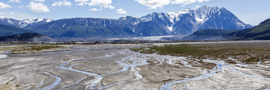
The Kaskawulsh Glacier has retreated so far that its meltwaters have altered course, transforming the regional drainage.
St. Elias Icefield
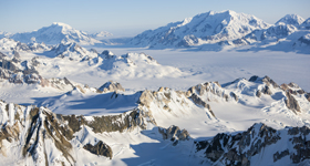
The icefields of the St. Elias mountains, a remnant of the ice sheets that once cloaked much of what-is-today Canada, are amongst the most expansive in the world and offer a window into our Ice Age past. Valley glaciers radiating out from the icefields, feed rivers flowing southward to the Gulf of Alaska and northward into the Yukon River, which flows westward through Alaska into the Bering Sea.
Since the end of the Ice Age, the volume of ice in the icefields has continually expanded and contracted in response to cyclic warming and cooling of the Earth’s climate over periods of hundreds of years. In concert, the valley glaciers, fed by the icefields, have advanced and retreated, working and reworking the architecture of their valleys – like gigantic bulldozers with each advance, and massive dump trucks, with each retreat.
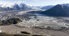
Kaskawulsh Glacier
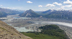
Flowing from the icefields, the Kaskawulsh Glacier forms the stem of a Y. From its toe the Kaskawulsh River flows southeastward, forming one arm of the Y. Downstream it merges with the Dezadeash River to form the Alsek River, which continues southward into the Gulf of Alaska.
The other arm of the Y is formed by the Ä’äy Chù (Slim’s River), which heads northwards from the toe of the glacier before emptying into Kluane Lake. Kluane Lake feeds the Kluane River, which flows into the White River, a tributary of the Yukon River which flows to the Bering Sea.
Advance and retreat
During glacial advances, the toe of the Kaskawulsh Glacier can advance right across the valley, separating the Kaskawulsh River valley from the valley of the Ä’äy Chù by a solid ridge of glacial ice. When this happens melt waters from the glacier flow in two directions: southeastward, down the Kaskawulsh River to the Alsek, and northward down the Ä’äy Chù into Kluane Lake.
When the Kaskawulsh Glacier retreats, a gap opens up between the toe of the glacier and the base of the mountain. Then, all that separates the Kaskawulsh River from the Ä’äy Chù is a jumble of rubble and ice left strewn across the valley floor by the retreating ice. And the melt water will do what it may. Generally it all flows down the shorter, steeper Kaskawulsh River into the Alsek. But at other times, the melt waters have continued to feed both the Kaskawulsh River and the Ä’äy Chù. That has been the case during the most recent retreat which started in the mid-19th Century, at the end of the “Little Ice Age”.
Stream capture
Since the middle of the 1950’s the retreat of the Kaskawulsh Glacier has accelerated. During that time two melt water lakes, separated by the ice and rock debris abandoned by the retreating glacier, have formed at its toe. One lake fed the Kaskawulsh River, the other the Ä’äy Chù. And then, in May of 2016, during an unusually warm spring, a meltwater channel formed through a section of dead ice separating the two lakes. Within a few days the channel became a gorge, diverting the water from the lake that fed the Ä’äy Chù into the lake that feeds the Kaskawulsh. The outlet at the head of the gorge is now 17 metres lower than the outlet which previously fed the Ä’äy Chù.
The remaining flow in the Ä’äy Chù, from sidestreams between the toe of the glacier and Kluane Lake, is drastically reduced, The level of Kluane Lake has dropped significantly, affecting access to and use of the lake. Longer term impacts on fisheries in the lake are unknown. Meanwhile, the head of the gorge which diverted the flow is lower than the current water level in Kluane Lake. Given enough time, “headward” erosion of the Kaskawulsh River will see it gradually capture the remaining flow of the Ä’äy Chù and eventually claim Kluane Lake as its headwaters and sever the connection to the Yukon watershed.
Before and after
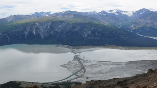
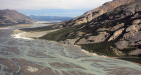
Kluane Lake and the mouth of the Ä’äy Chù
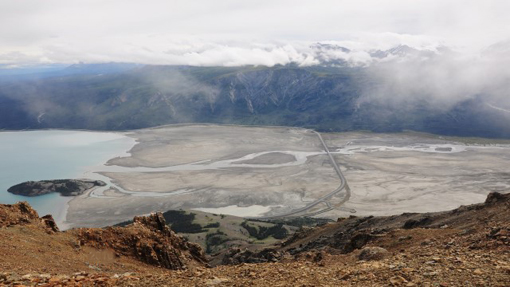
Kluane Lake and the mouth of the Ä’äy Chù
Back to the future
Stream capture, or “river piracy” as it has sometimes been dubbed, has not been seen in the modern era, though it was not uncommon as the world emerged from the grips of the last great Ice Age. It would take nothing less than a major re-advance of the Kaskawulsh Glacier to reverse the process. Given the current industrially-driven warming of the climate that seems like a remote possibility in the foreseeable future. Perhaps this throwback to the end of the Ice Age is a harbinger of things to come. Perhaps, we are entering a new age.
Learn more
Related links
- Date modified :